
http://antarvasnavideos.pro sex videos kinky babe fisting her large pussy. https://bigboobslovers.net/ hungry mom loves throat fucking.

Workshop on Standardization of procedures in using UAS for environmental monitoring – Coimbra 2019
19 November 2019
An Evaluation of Image Velocimetry Techniques under Low Flow Conditions and High Seeding Densities Using Unmanned Aerial Systems
9 January 2020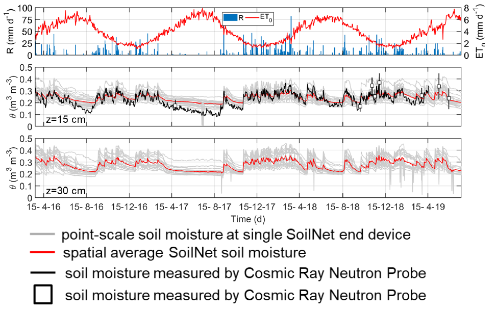
The iAQUEDUCT project activities in a small Mediterranean rural catchment: Preliminary results of field and remote sensing campaigns to parameterize Richards-based hydrological models
The EU Water-JPI project titled “An integrative information aqueduct to close the gaps between global satellite observation of water cycle and local sustainable management of water resources – iAQUEDUCT” aims primarily at closing the gaps between remote observations of water cycle and local needs of information for sustainable management of water resources. Specifically, the objectives are to combine Copernicus satellite data with high-resolution Unmanned Aerial System (UAS) and in-situ observations to develop scaling functions for soil properties, soil moisture, and evapotranspiration at high spatial resolution meter scales. Regarding the use of UAS techniques, this project has very fruitful links and strong collaborations with the EU COST-Action “HARMONIOUS: Harmonization of UAS techniques for agricultural and natural ecosystems monitoring”, acting in such a way to gather scientists, having various backgrounds and experiences, around the common topic of enhancing the use of different types of environmental observations, harmonizing monitoring practices, and increasing understanding of interactive agro-hydrological processes.
Within the main objectives of this project, some integrated investigations were already started at MFC2 that is a small sub-catchment pertaining to the Alento Hydrological Observatory. The test site is located in the Upper Alento River basin in southern Italy, has a drainage area of approximately 8 hectares, and is representative of agricultural hilly lands subject to the typical Mediterranean climate.
The present contribution shows some preliminary results about an experimental protocol set-up to parametrize hydrological models in cost-effective and efficient ways. The protocol considers collecting soil physical, thermal, and hydraulic properties both in-situ and from UAS sensing. Basic and advanced pedotransfer functions (PTFs) together with spectroscopy are used to enrich the measured attributes with soft information, thus enhancing properly the input model requirements. Soil moisture sensor networks and a complete weather station provide data on the state of the system and boundary conditions. We envisage to apply two Richards-based hydrological models: the STEMMUS and HydroGeoSphere models.

How to cite: Nunzio Romano, Paolo Nasta, Zhongbo Su, Yijian Zeng, Salvatore Manfreda, Ruodan Zhuang, Brigitta Toth, János Mészáros, Eyal Ben-dor, Nicolas Francos, Antonino Maltese and Giuseppe Ciraolo, PA13B-1016The iAQUEDUCT project activities in a small Mediterranean rural catchment: Preliminary results of field and remote sensing campaigns to parameterize Richards-based hydrological models, AGU 2019.
Attachments
| # | File | Description | Date added | Added by | File size | Downloads |
|---|---|---|---|---|---|---|
| 1 |
 AGU2019_RomanoN_iAqueduct-AlentoBasin
|
12 December 2019 9:53 | Salvatore Manfreda | 3 MB | 775 |
Related posts


website
big black teen apparel theft.http://desivideos4k.com/ cassandra nix and eva karera threesome.