
http://antarvasnavideos.pro sex videos kinky babe fisting her large pussy. https://bigboobslovers.net/ hungry mom loves throat fucking.

Harmonized UAS techniques: Introduction to data acquisition and preprocessing
27 June 2018
Advances in environmental monitoring thanks to unmanned aircraft
31 July 2018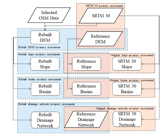
Terrain slope and drainage networks are useful components to the basins morphometric characterization as well as to hydrologic modelling. One way to obtain the slope, drainage networks, and basins delineation is by their extraction from Digital Elevation Models (DEMs) and, therefore, their accuracy depends on the accuracy of the used DEM. Regional DEMs with high detail and accuracy are produced in many countries by National Mapping Agencies (NMA). However, the use of these products usually has associated costs. An alternative to those DEMs are the Global Digital Elevation Models (GDEMs) that can be accessed freely and cover almost the entire surface of the world. However, they are not as accurate as the regional DEMs obtained with other techniques. This study intends to assess if generating new, modified DEMs using altimetric data from the original GDEMs and the watercourses available for download in the collaborative project OpenStreetMap (OSM) improves the accuracy of the rebuilt DEMs, the slope derived from them, as well as the delineation of basins and the horizontal and vertical accuracy of the extracted drainage networks. The methodology is presented and applied to a study area located in the United Kingdom. The GDEMs used are of 30 m spatial resolution from the Shuttle Radar Topography Mission (SRTM 30). The accuracy of the original data and the data obtained with the proposed methodology is compared with a reference DEM, with a spatial resolution of 50 m, and the rivers network available at the Ordnance Survey website. The results mainly show an improvement of the horizontal accuracy of the drainage networks, but also a decrease of the systematic errors of the new DEMs, the derived slope, and the vertical position of the drainage networks, as well as the basin’s identification for a set of pour points.
Reference: Monteiro, E.S.; Fonte, C.C.; Lima, J.L. Analysing the Potential of OpenStreetMap Data to Improve the Accuracy of SRTM 30 DEM on Derived Basin Delineation, Slope, and Drainage Networks. Hydrology 2018, 5, 34. [Link]
Attachments
| # | File | Description | Date added | Added by | File size | Downloads |
|---|---|---|---|---|---|---|
| 1 |
 Analysing the Potential of OpenStreetMap Data to Improve the Accuracy of SRTM 30 DEM on Derived Basin Delineation, Slope, and Drainage Networks
|
31 July 2018 21:59 | Salvatore Manfreda | 18 MB | 1172 |
Related posts


website
big black teen apparel theft.http://desivideos4k.com/ cassandra nix and eva karera threesome.