
http://antarvasnavideos.pro sex videos kinky babe fisting her large pussy. https://bigboobslovers.net/ hungry mom loves throat fucking.

Special Issue on RS entitled Global Gridded Soil Information Based on Machine Learning
14 May 2021
General Assembly – Remote Sensing of the Environment using Unmanned Aerial Systems (UAS)
24 June 2021
Unmanned Aerial Systems (UAS) play an increasingly important role in collecting data for environmental monitoring. The primary challenges for UAS in environmental studies include creating consistent, standardised guidelines for data collection and establishing practices that apply to a range of environments. Dr Salvatore Manfreda from the University of Naples Federico II, along with the HARMONIOUS team, identified critical steps in planning, acquiring, and processing UAS data to ensure best practices and a streamlined, effective workflow.
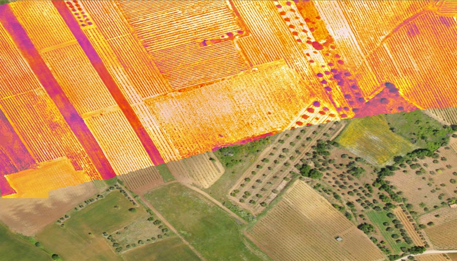
As drone technology has improved over the last decade, Unmanned Aerial Systems (UAS) have become a fundamental part of environmental monitoring, bridging the gap between traditional field studies and satellite remote sensing. UAS is an inexpensive way of acquiring visual data on a large temporal scale across the electromagnetic spectrum, making it an invaluable technology for monitoring dynamic environmental processes.
UAS can provide real-time aerial photography or video to map and monitor natural and artificial ecosystems, giving a unique insight into the environment. The versatility, adaptability, and flexibility of UAS make them an essential tool for environmental studies such as forestry planning, tracking glacier geomorphology and precision agriculture, to name but a few applications.
The continual improvements in UAS and sensor technologies, coupled with the variety of environmental settings in which they are deployed, have led to a diversity of methodologies in how data is collected, analysed, and processed. The inconsistencies in the UAS study designs have triggered multiple issues regarding the quality of the final imagery and data collected and have led to overblown budgets. These issues highlighted the necessity for a standardised protocol in UAS environmental mapping and monitoring to be developed.
There are clear economic, temporal and qualitative benefits in using UAS over satellites or manned aircraft.
Dr Manfreda from the University of Naples Federico II, with the international team of researchers of the HARMONIOUS COST Action, explored the primary issues in utilising UAS in environmental studies and produced guidance to improve planning, acquisition, and processing of data and the quality and reproducibility of research. They created a generalised workflow methodology with five interconnected steps:
- study design;
- pre-flight fieldwork;
- flight mission;
- processing of aerial data;
- quality assurance.
UAS limitations
There are clear economic, temporal, and qualitative benefits in using UAS over satellites or manned aircraft, which are limited by their cost and how often a survey can use them. However, as UAS is still an immature technology, limitations exist in how data is collected and analysed.

Previous studies have indicated that many UAS surveys fail to consider the planning and processing of UAS imagery. When the speed and height of the UAS and the calibration of the sensors are not considered in the planning stage, and the weather is not accounted for on the day of the flight, the UAS imagery will be blurred or of incorrect resolution.
These limitations could be mitigated through a structure of standardisation which can work as a checklist for UAS surveys to ensure accurate collection and analysis of data.
Standardising UAS data collection
Although every UAS survey will be slightly different owing to the wide variety of vegetation, topography, climate, and local legislation in study environments, a standardised workflow, which accounts for every stage of the survey and applies to every environment, will be incredibly beneficial in assuring appropriate planning for high-quality results.

Through creating a generalised workflow in five interrelated steps, HARMONIOUS’s research aims to improve the final quality of data and analysis. The workflow was designed based on harmonising multiple methods collated from recent research and reviews of different UAS surveys.
Workflow design
Every UAS study can vary greatly and therefore requires a bespoke study design to set out a detailed mission plan for the study area. Consequently, the initial step in the workflow process is to design the study; this step is essential to set up the parameters of the survey and consider the specifics of the environment and the research question as this will shape where, how, and when the flight can take place and what sensors will be used.
When all factors are considered, the study design can be an incredibly complex problem. The final quality of the model is dependent on all of these interconnected factors being correctly accounted for.
In general, mission plans for environmental studies focus on four primary elements:
- UAS regulations and legislation;
- platform and sensor choice;
- camera settings and UAS control software;
- target geo-referencing.

Local UAS regulations and legislation will have to be understood first to ensure the mission will get permission to fly in the study area. The platform, sensor, camera settings, and UAS control software choices are purely dependent on the survey’s requirements and limitations – concerning budget and time limitations, or the image quality, spectral and spatial resolution, and the survey area’s size. Finally, in the study design, target geo-referencing must be conducted to ensure the imagery is taken correctly. The best way to do this is to find ground control points (GCP) for reference.
Once the study design is complete, the next step in the workflow is to conduct a pre-flight study. This section of the workflow entails reconnaissance and a terrestrial survey of the survey area. The area’s reconnaissance will reveal take-off and landing points, any possible visual or flight obstructions, and any GCP’s for the flight to be geo-referenced. The field study will be highly dependent on the environmental medium being studied but will supplement and influence any data collected from the UAS study.
The researchers have created a harmonised workflow that will be an essential element of any UAS survey in the future.
Following the pre-flight, the workflow explains how to safely and most effectively conduct the flight itself. The challenge at this stage is to account for the weather accurately. Wind speed, humidity, light levels, and fog can affect data quality, so it must be compensated for before the flight takes place.
The final stage in the workflow describes how to best process the imagery and data from the flight. When processing, it is essential for the surveyors to account for the distortions, often in UAS imagery. These can misrepresent the radiometrics and geometrics of the study object. However, a series of steps quantify the radiometric or geometric problems, for which there is a corrective method.

A critical aspect of HARMONIOUS’s method is that quality assurance must be evaluated at every step to guarantee a quality survey outcome. One such way alluded to, which can save time and money and ensure quality images, uses a portable resolution test chart. These charts, when used correctly, can give assurances that cameras are calibrated correctly before the flight takes place.
A new standard practice
Recent advances in UAS have meant that low-cost and near real-time data collection has become possible in an array of environmental studies. With their essential work, Dr Manfreda and his fellow researchers have created a harmonised workflow and accompanying checklists that will be a vital element of any UAS survey in the future, furthering the efficacy of UAS and making them a more valuable tool in studying the environment.
The researchers have designed the workflow to reduce error in data collection and processing and ensure flights are conducted within budget, safely, and effectively. This research will undoubtedly improve future UAS studies and be a template by which all reviews can be guided, streamlining the study process and making results easily reproducible.
HARMONIOUS’s research assists in furthering UAS procedures and ensuring that UAS studies in the future will have more accurate results if they utilise the workflow checklists referenced in this article.

Personal Response
As new iterations of UAS technologies are developed, could the workflow process become more automated?
We are now focusing on the preparation of a book edited by Elsevier providing more detailed guidelines for UAS applications in environmental monitoring.
Attachments
| # | File | Description | Date added | Added by | File size | Downloads |
|---|---|---|---|---|---|---|
| 1 |
 2021_Salvatore Manfreda_1[175308]
|
21 May 2021 15:02 | Salvatore Manfreda | 1 MB | 611 |
Related posts

website
big black teen apparel theft.http://desivideos4k.com/ cassandra nix and eva karera threesome.