
http://antarvasnavideos.pro sex videos kinky babe fisting her large pussy. https://bigboobslovers.net/ hungry mom loves throat fucking.

Our Book is climbing the rankings on Google
20 April 2023
Detection of Surface Water and Floods with Multispectral Satellites
23 May 2023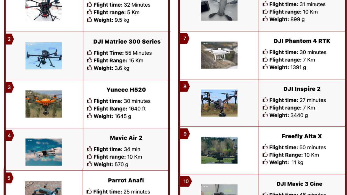
Mapping drones have revolutionized the way we capture geographic data and create precise maps and models for various purposes. These unmanned aerial vehicles (UAVs) are equipped with specialized sensors and cameras, making them essential tools for industries ranging from surveying to infrastructure inspection. Here’s a list of some of the best drones for mapping in 2023:
1) MATRICE 600 PRO:
– Manufacturer: DJI
– Features: Versatile hexacopter with powerful payload capacity, ideal for mapping professionals.
2) DJI Matrice 300 Series:
– Manufacturer: DJI
– Features: Advanced commercial drone with outstanding flight capabilities and a range of payload options.
3) Yuneec H520:
– Manufacturer: Yuneec
– Features: Reliable and adaptable hexacopter designed for precise data collection and mapping.
4) Mavic Air 2:
– Manufacturer: DJI
– Features: A compact and affordable option with impressive camera capabilities, suitable for small-scale mapping projects.
5) Parrot Anafi:
– Manufacturer: Parrot
– Features: Portable, foldable, and easy-to-use quadcopter with a 4K camera for mapping and surveying tasks.
6) DJI Mavic 2 Enterprise:
– Manufacturer: DJI
– Features: A versatile quadcopter designed for professional applications, including mapping, inspection, and search and rescue.
7) DJI Phantom 4 RTK:
– Manufacturer: DJI
– Features: High-precision RTK capabilities for accurate mapping and surveying tasks.
8) DJI Inspire 2:
– Manufacturer: DJI
– Features: A powerful platform with interchangeable cameras suitable for various mapping and cinematography needs.
9) Freefly Alta X:
– Manufacturer: Freefly
– Features: A flexible and customizable drone platform that can be equipped with mapping payloads.
10) DJI Mavic 3 Cine:
– Manufacturer: DJI
– Features: A high-end quadcopter with impressive camera capabilities, suitable for professional mapping and aerial photography.
When selecting a mapping drone, consider factors such as camera quality, flight time, payload capacity, and the specific requirements of your mapping project. Additionally, it’s essential to ensure compliance with local regulations and obtain the necessary permits for drone operations.
Mapping drones continue to evolve, offering innovative solutions for industries that require precise geospatial data. Whether you’re a surveyor, an infrastructure inspector, or a mapping enthusiast, these drones can be valuable assets in your toolkit. Make an informed choice based on your needs, and let technology take your mapping projects to new heights! 

Related posts


website
big black teen apparel theft.http://desivideos4k.com/ cassandra nix and eva karera threesome.